
WSGS Publishes New Study of Tensleep Aquifer in Wyoming
Wyoming State Geological Survey
August 17, 2026
FOR IMMEDIATE RELEASE
Media Contact:
Bryce Tugwell, Publications and Outreach Manager
bryce.tugwell@wyo.gov
Wyoming State Geological Survey
Office: (307) 745-2236
www.wsgs.wyo.gov
WSGS Publishes New Study of Tensleep Aquifer in Wyoming
LARAMIE, Wyo. — The Wyoming State Geological Survey (WSGS) has published a new study compiling hydrogeologic information about the Tensleep aquifer and equivalent rock units across Wyoming.
Hydrogeologic Parameters for the Tensleep Aquifer in Wyoming, by WSGS hydrogeologists Kurt Hinaman and James Stafford, brings together existing data on porosity, permeability, groundwater recharge, water quality, temperature, and groundwater interaction with oil fields. The Tensleep Sandstone and equivalent formations constitute a major aquifer system across Wyoming, with the study examining hydrogeologic conditions throughout the system.
The report examines how hydrogeologic conditions vary across the aquifer system. Porosity and permeability generally decrease with depth. Additionally, the study identifies areas with high estimated long-term groundwater recharge in portions of the Bighorn Mountains, Wyoming Range, and Gros Ventre Range.
“Much of the information about the Tensleep aquifer has been collected over many decades for different purposes,” Hinaman said. “This report brings those datasets together so we can better understand how the aquifer and its equivalent units vary across Wyoming.”
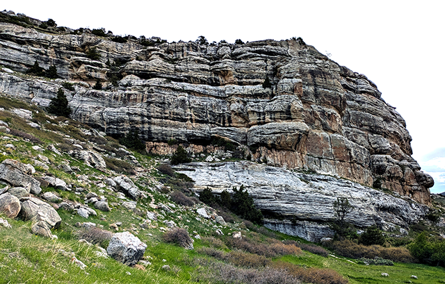 The Tensleep Sandstone in Sinks Canyon State Park, southwest of Lander, Wyoming.
Throughout much of Wyoming, groundwater salinity generally increases from mountain flanks toward deeper portions of sedimentary basins. The study also found that sodium-adsorption ratios generally increase farther from mountain fronts, making groundwater from the aquifer less suitable for irrigation in many areas. Lithium concentrations were generally low, although data are limited in deeper portions of the state’s sedimentary basins.
One of the study’s more unusual findings occurs in the northeastern Powder River Basin, where groundwater in the Minnelusa Formation, an equivalent of the Tensleep, has exceptionally high salinity but is cooler than expected for its depth. The two anomalies occur in roughly the same area, although the cause of the cooler temperatures remains unknown.
The report is the first in a planned series of WSGS studies characterizing individual aquifers in Wyoming. Future studies are intended to support comparisons among aquifers and improve understanding of groundwater chemistry and the effectiveness of confining units between them.
Hydrogeologic Parameters for the Tensleep Aquifer in Wyoming, WSGS Open File Report 2026-1, is available to download for free from the WSGS website: https://www.wsgs.wyo.gov/pubs-maps/publication-search.aspx?PubID=OFR-2026-1.
Legal Disclaimer:
EIN Presswire provides this news content "as is" without warranty of any kind. We do not accept any responsibility or liability for the accuracy, content, images, videos, licenses, completeness, legality, or reliability of the information contained in this article. If you have any complaints or copyright issues related to this article, kindly contact the author above.
